***Update 1
On 11/27, a pre-ride of the Tscheschter Kaundi 200 route was completed by Brad Layman, Iwan Barankay, and Pat Gaffney. It was a blustery day. If the weather turns out to be similar on the day of the event, be prepared for some challenging winds from the west, particularly on the segment from Doe Run to Atglen because the terrain opens up to exposed farmland. Cafe Metzler was a lifesaver to these riders.
Overall, the course is good shape. Small tweaks were made to some cues to make navigation clearer. The route remains mostly intact from the original but be sure to have VERSION 3 of the cuesheet and the latest RWGPS file, last modified 2021-11-28 14:13:19 EST. Be alert for changes.
 |
| A peaceful road in Tscheschter Kaundi |
Course notes:
The parking lot of the theater, Cadence Cycling, and Fine Wine & Good Spirits is easy to spot from Main Street. Please park away from the businesses and close to Main Street. The organizer will be there bright and early so you can look for him to be sure that you park in the right area. Note that there are no bathroom facilities at the start. The closest convenience store with a bathroom is the Shell/Dunkin (4268 Ridge Ave) in East Falls.
The parking lot of the theater, Cadence Cycling, and Fine Wine & Good Spirits is easy to spot from Main Street. Please park away from the businesses and close to Main Street. The organizer will be there bright and early so you can look for him to be sure that you park in the right area. Note that there are no bathroom facilities at the start. The closest convenience store with a bathroom is the Shell/Dunkin (4268 Ridge Ave) in East Falls.
 |
| Parking lot of start control |
Be prepared for some urban riding from the start. Typically, MLK Drive is open to traffic on weekends from November through March, but the city stated during the pandemic that it was going to “experiment” with closing the drive every weekend year round, leaving a bit of uncertainty. MLK Drive was closed to traffic on the pre-ride, which was also on a Saturday. You will be able to tell when you cross the Falls Bridge and turn left: if the gate is closed, the road is all yours. If the gate is open, you can ride in the new bike lane on MLK Drive or use the freshly paved trail to the left of the road. The southern mile of the drive is definitely closed to traffic because of an issue with the bridge that crosses the Schuylkill near the Art Museum. However, it is open to cyclists and pedestrians. There are barricades to detour the cars at the intersection of Sweetbriar Drive, but riders can get through by riding around them on the left side. After crossing the bridge over the Schuylkill, look for the pergola on the right, where we turn and get on the Schuylkill River Trail heading south.
After the photo control on the South St Bridge, the route moves to city streets with bike lanes. Be careful crossing the intersection of expressway ramps on the South St Bridge - wait for green straight arrows. When turning left on 40th St and right on Baltimore Ave at mile 7.6, be extra cautious as you cross junctions of trolley tracks. Also be cautious in the bike lane of Baltimore Ave because you will have limited space to maneuver if encountering an errant driver or wandering pedestrian due to parked cars to your right and trolley tracks to your left. Ride slowly when crossing intersections with turning trolley tracks and when crossing the tracks to turn left onto Whitby Ave (mile 8.9).
After crossing Cobbs Creek we enter Delaware County and ride through some of the denser communities of the county. The route follows the “Bicyclists Baltimore Pike” to Swarthmore, which is marked with street signs. After Swarthmore, the route crosses Crum Creek and passes through quiet neighborhoods around the edge of the DelCo seat, Media. Look for the Giant Sequoia in the Tyler Arboretum on the right around mile 23.7.
There is a Wawa on the left side of Dilworthtown Rd near mile 32. This is the last chance to resupply before Cafe Metzler at mile 63. We enter Tscheschter Kaundi here upon crossing busy Wilmington Pike/PA-322.
The next section is a peaceful stretch along Brandywine Creek. There is a road closure sign at the intersection of Embreeville and Stargazers Rds which you can ignore. The closure signs are there due to a closed bridge another mile down Embreeville Rd. We were able to maneuver through the bridge barricades, so a detour was not made to the route. If a detour becomes necessary, riders can backtrack to Harveys Bridge Rd, make a left at the next bridge, and left on Brandywine Creek Rd which will bring you back to the course.
After the photo control on the South St Bridge, the route moves to city streets with bike lanes. Be careful crossing the intersection of expressway ramps on the South St Bridge - wait for green straight arrows. When turning left on 40th St and right on Baltimore Ave at mile 7.6, be extra cautious as you cross junctions of trolley tracks. Also be cautious in the bike lane of Baltimore Ave because you will have limited space to maneuver if encountering an errant driver or wandering pedestrian due to parked cars to your right and trolley tracks to your left. Ride slowly when crossing intersections with turning trolley tracks and when crossing the tracks to turn left onto Whitby Ave (mile 8.9).
After crossing Cobbs Creek we enter Delaware County and ride through some of the denser communities of the county. The route follows the “Bicyclists Baltimore Pike” to Swarthmore, which is marked with street signs. After Swarthmore, the route crosses Crum Creek and passes through quiet neighborhoods around the edge of the DelCo seat, Media. Look for the Giant Sequoia in the Tyler Arboretum on the right around mile 23.7.
 |
| Giant Sequoia, Tyler Arboretum |
The next section is a peaceful stretch along Brandywine Creek. There is a road closure sign at the intersection of Embreeville and Stargazers Rds which you can ignore. The closure signs are there due to a closed bridge another mile down Embreeville Rd. We were able to maneuver through the bridge barricades, so a detour was not made to the route. If a detour becomes necessary, riders can backtrack to Harveys Bridge Rd, make a left at the next bridge, and left on Brandywine Creek Rd which will bring you back to the course.
 |
| Embreeville Rd Bridge is passable |
There is a bridge with a metal grate surface crossing Doe Run at mile 51.1. The miles from here until Cafe Metzler are tough if there are strong winds from the west.
Cafe Metzler is easy to spot on the right as you approach on Noble Road. Look for the garage at the bottom of the driveway. Be sure to thank George for opening Cafe Metzler for us.
Once you reach Ludwigs Corner around mile 91, it is mostly downhill and then flat. For the photo control, take a picture of the Sheeder Hall Bridge - do not cross the bridge. A short and smooth gravel section follows. There is a bridge with a metal grate surface following a bend at mile 98.3. Bridge Street in Phoenixville is closed to traffic but passable on bike. Ride slowly and be respectful of the pedestrians enjoying their night on the town. Once you cross the Schuylkill River, follow Walnut St and Port Providence Rd to the SRT. There has been a "Trail Closed" sign at the Port Providence Trailhead of the SRT since the area was damaged by Hurricane Ida in September, but the trail is passable with minimal obstruction.
 |
| Sheeder Hall Bridge (photo control) |
There is a new trail pattern in Norristown. Riders who know the SRT well know to be prepared for a sharp right after crossing the bridge over Rt 202. Instead of a right turn, the trail follows a new S shape pattern. It is easy to navigate but might surprise riders who know the old pattern or pass through at night. The section just opened and has not yet been updated on maps, so the organizer did his best to draw the approximate route line on the RWGPS map.
The route follows the gravel Manayunk Towpath from Shawmont Ave to Lock St. Be cautious after crossing Shawmont Ave: there is a downhill section that crosses train tracks and cobblestones and then through bollards to get on the towpath. It is a tricky section, especially in the dark. Two miles later, make the left on Lock St and then right on Main Street and follow it back to the parking lot where we started. When you turn right into the parking lot, look for the Pencoyd Bridge. You can ride the wide sidewalk or the road across the bridge, but note that the roadway is only wide enough for one car. Be careful of bollards if using the sidewalk. The Landing Kitchen is on the left after crossing the bridge. The cafe is closed from 4-4:30pm. During that time, volunteers will be sitting on the patio outside the cafe awaiting early finishers.
***Original Post
The Pennsylvania Randonneurs’ 2021 finale brings riders back for another start/finish in Philadelphia on December 4 at 7am. Inspired by the PA Dutch name for Chester County, this ride will take you through the county and on towards PA Dutch Country.
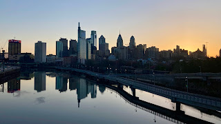 |
| Center City from South St Bridge |
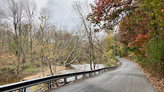 |
| Creek Rd along the Brandywine |
With less than 10 hours of daylight available, riders will need lights and reflective gear.
A pre-ride is being planned on November 27 which may result in additional clarifying notes. Event details and registration are available on the website. Registration is open until midnight on Wednesday, December 1.
Brad Layman
Event Organizer
No comments:
Post a Comment