The starting time for the Fall Classic 200K has been changed to 6AM. Please take note of this change. We moved the start earlier so as to allow most riders to finish in the daylight. Of course, this means the ride starts before dawn -- everyone must have lights and reflective gear at the 200K start. The start time for the 154K Populaire remains 7:30 AM. Register for the 200K or 154K at parando.org.
154K Course Notes ---
The latest Cue Sheet for the 154 K is VERSION 3, and the latest RWGPS was last modified 2021-03-26 19:33:22 EDT. Be alert for changes if we discover the bridge won't be passable next Saturday. See notes below.
On 11 October a partial pre-ride of the 154K course was ridden by yours truly, Chris Nadovich. I checked out the section of the 154 that is not the same as the 200K. Here are my comments.
There's a problem on Little Creek Rd, not far past mile 15. This issue only affects the 154K, not the 200. There's a section under construction. I was able to walk through the construction with little trouble. There were guys actively working, putting down straw over the landscaping next to the road. The roadway itself was not paved yet -- but it was graded smooth with hard stone grit and it looked like gravel and blacktop might be the next step. Paving could happen this week -- I asked, but nobody knew for sure.
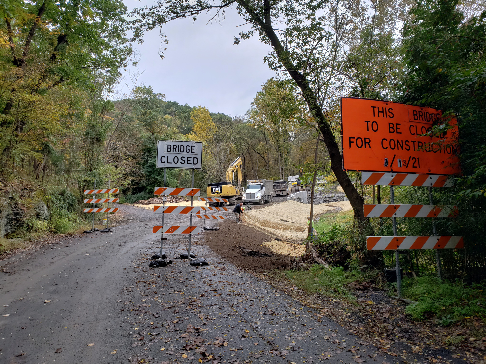 |
| Bridge on Little Creek Rd |
I'm thinking positive waves and hoping Little Creek Rd is passable next Saturday. It's such a nice road otherwise, and the detour options are unpalatable.
Please read the 200K notes below for more warnings, particularly the sand and gravel at the start of Mountain View Drive. The 154K is almost an identical to the 200K, except that after the Tatamy it splits off to avoid Wind Gap and Fox Gap. It then rejoins the 200K at Belvidere.
200K Course Notes ---
The latest Cue Sheet for the 200 K is VERSION 4, and the latest RWGPS was last modified 2021-10-3 09:55:14 EDT.
On 2 October a pre-ride of the 200K course was ridden by yours truly, Chris Nadovich. Here are my comments.
This course is a classic for a reason: classic scenery, classic landmarks, and plenty of classic climbs. Ho boy, are there climbs. I do think this course is harder than the Pagoda. On the other hand, I think this course is also prettier than the Pagoda course. So many classic views. I think I could see just a touch of orange along the crest of the Mt Minsi ridge. In two weeks I'd expect a lot more Fall Color. It should be spectacular.
PA Rando veterans will be familiar with most of the features in this course. We've been using the Two Rivers and Plainfield rail trails for quite a while now. The climb over Wind Gap and the right turn onto Cherry Valley Rd by the winery is something we've done 1000 times.
Yes, the climb up Fox Gap is just as hard as always. And yes, the shoulder up Fox Gap is still moderately littered with debris. I've seen it worse. Nevertheless, do be on the lookout for sticks, rocks, and a ton of these spherical tree droppings: acorns, chestnuts, and the like. They probably won't cause you to fall directly, but it can be a little unsettling when your bike suddenly leaps 6 inches to the right or left, unexpectedly, as you roll of some of these.
After the control at Portland (a historical marker on the right, just before the 611 on-ramp) the course does not follow the river all the way to Belvidere. Instead, it takes a "short cut" almost 2 miles shorter -- honest. You might not be happy about this short cut as you climb up Pine Tree Rd, but try to remember, you could have had the dirt-road Marshfield climb we used in the past. Pine Tree is nicely paved.
The reward for the climb up Pine Tree is the charming descent along Allegheny Creek on Shady Lane. WARNING: The left turn onto Shady Lane is very tricky. You will be coming down the hill on Sunrise, picking up speed, when you encounter a set of S-curves. The left onto Shady Lane is immediately after these S-curves, so SLOW DOWN as you enter these curves and don't speed up again till after you've safely negotiated the left onto Shady Lane.
The next set of climbs are just as you remember them. Lommanson Glen, Mountain View, and Tunnel. Other than the exertion of climbing, and exhilaration of descending, these features are unremarkable except for the entrance to Mountain View Rd off of Good Springs. The left turn onto Mountain View is covered with sand and gravel. It's very deep sand and gravel -- like 2+ inches deep. I had to steer a cautious line through it. You might consider just walking through it, considering you'll be dismounting in about 100 feet anyway. The initial part of Mountain View is very steep. Some riders have walked this section -- I've been told.
Once you get over Tunnel Rd to Milford Market, almost all the big stuff is behind you. Ahead of you are a bunch of classic Bucks County cycling roads. Occasional rollers and short climbs, but mostly just pleasant countryside to ride through on a Fall afternoon.
The southernmost control, the Dairy Queen in the town of Dublin, is a little tricky to access. Make the hard right at the light through the 5-points intersection, and immediate left into the DQ. When leaving, do not retrace that path. Rather, cross the street at the DQ and go to the left of the hardware store, cutting across to make a left on Elephant Rd.
I saw some construction on Elephant Rd. I passed "Road Closed" signs and encountered a milled section of pavement. It appears they are planning some paving on Elephant in the near future. I doubt this will impact our ride on a Saturday. No Detour was offered by the construction signs, but you should be able to backtrack to Blue School to get around if this is a problem.
Immediately after the control at the Weisel Hostel is a covered bridge. This bridge is extremely bumpy. It's not a problem to ride over if you are going slow, but if you hit that bridge going faster than 10 mph you probably will blow a tire, go down, or both. When you see that covered bridge immediately after making the right on Covered Bridge Rd after the Hostel -- SLOW THE F DOWN!
Soon after that bumpy bridge, the last challenging section of course begins. This starts with Gallows Hill, which may not seem like downhill, but basically is. PA Rando veterans will see Buck Wampum on the left and nod knowingly. We ride part way down (sic) Lennenberg, taking a left on the un-paved Coon Hollow. This gravel road is basically smooth, but it's downhill and there are a few potholes to look out for till it becomes paved approaching Durham Furnace. From there, it's over the two humps needed to cross back into the Lehigh Valley. In the past we have taken Lower Saucon past Wassergass, but I think this new routing up from Durham, and then up Morgan Hill and Cider Press, is easier.
At the very end of the ride, immediately after crossing the 25th St bridge over the river and your parked car, you will turn right into the Easton Children's Home private drive. There are two speedbumps before you take your first right down a very steep connector trail. At the bottom of the connector, T-left onto the D&L trail proper. Go very slow down that connector trail. It was clean when I rode it, but it often has some debris on it. The turn at the bottom is a very sharp and quick left. GO SLOW. One may question why we take this crazy connector trail, but as crazy as it is, I think it's safer and easier than crossing 4 lanes of 25th street to make a left instead, back at the end of the bridge.
Enjoy the ride!
--
Chris N
No comments:
Post a Comment